Gobeklitepe … a pre-historic site, about 15 km away from the city of Sanliurfa, Southeastern Turkey. What makes Gobeklitepe unique in its class is the date it was built, which is roughly twelve thousand years ago, circa 10,000 BC.
Archaeologically categorised as a site of the Pre-Pottery Neolithic A Period (c. 9600–7300 BC) Göbeklitepe is a series of mainly circular and oval-shaped structures set on the top of a hill. Excavations began in 1995 by Prof. Klaus Schmidt with the help of the German Archeological Institute. There is archelological proof that these installations were not used for domestic use, but predominantly for ritual or religous purposes. Subsequently it became apparent that Gobeklitepe consists of not only one, but many of such stone age temples. Furthermore, both excavations and geo magnetic results revealed that there are at least 20 installations, which in archeological terms can be called a temple.
Based on what has been unearthed so far, the pattern principle seems to be that there are two huge monumental pillars in the center of each installation, surrounded by enclosures and walls, featuring more pillars in those set-ups.
All pillars are T-shaped with heights changing from 3 to 6 meters. Archeologists interpret those T-shapes as stylized human beings, mainly because of the depiction of human extremities that appear on some of the pillars. What also appears on these mystical rock statues, are carvings of animals as well as abstract symbols, sometimes picturing a combination of scenes.
Foxes, snakes, wild boars, cranes, wild ducks are most common. Most of these were carved into the flat surfaces of these pillars. Then again, we also come across some three-dimensional sculptures, in shape of a predator depicting a lion, descending on the side of a T-pillar.
The unique method used for the preservation of Gobeklitepe has really been the key to the survival of this amazing site. Whoever built this magnificent monument, made sure of its survival along thousands of years, by simply backfilling the various sites and burying them deep under, by using an incredible amount of material and all these led to an excellent preservation.
Each T-shaped pillar varies between 40 to 60 tonnes, leaving us scratching our heads as to how on earth they accomplished such a monumental feat. In a time when even simple hand tools were hard to come by, how did they get these stone blocks there, and how did they erect them? With no settlement or society to speak of, with farming still a far cry away, in a world of only roaming hunter-gatherers, the complexity and developed blueprints of these temples represented another enigma for archeologists.
History Channel Documentary about all Cappadocia area
Derinkuyu is amazing widely huge underground city. History Channel made a nice documentary about it.
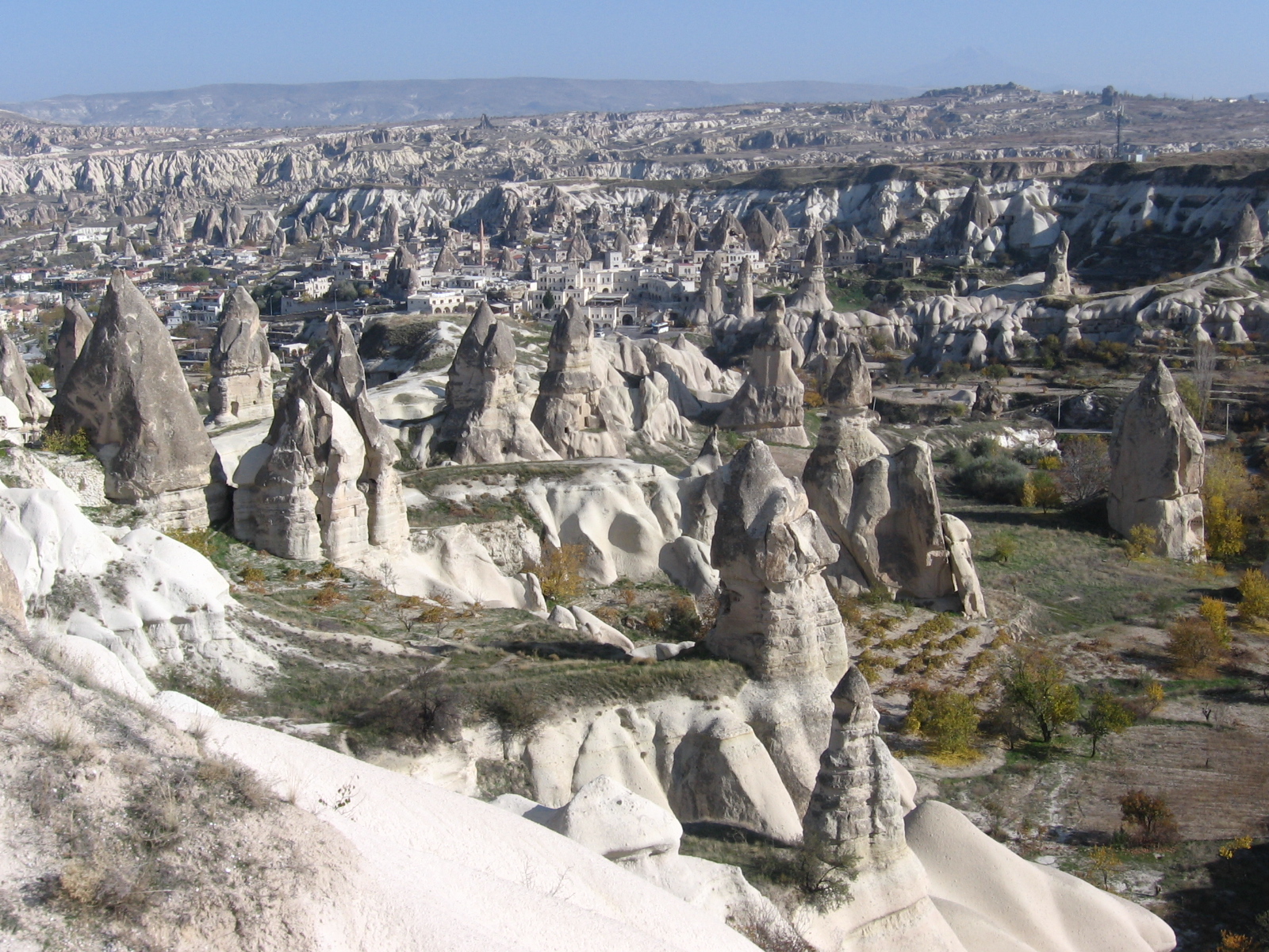
Cappadocia which is unique in the world and is a miraculous nature wonder is the common name of the field covered by the provinces of Aksaray, Nevsehir, Nigde, Kayseri and Kirsehir in the Central Anatolian region.
In the upper Myosen period in the Cappadocia region as a result of the vulcanic eruptions occurred in Erciyes, Hasandag and Gulludag, in the region was formed a large tableland from the vulcanic tufas and together with the erosion of the Kizilirmak river and wind over ten thausands of years there appeared the chimney rocks which are a wonder of the nature. In the old Bronze Age the Cappadocia which was the population zone of the Assyrian civilization later has hosted the Hittite, Frig, Pers, Byzantine, Seljuk and Ottoman civilizations. The first Christians escaped from the persecution of the Roman Empire in the 2nd century B.C. came to the Cappadocia over the Antakya and Kayseri and they have settled here. The first Christians finding the underground cities from Cappadocia have been hidden in these underground cities which gates were made in such way in which they couldn't be easily observed and they have escaped from the persecution of the Roman soldiers. Due that they had live in the underground cities for long duration without being able to go out they have developed these underground cities by making provisions rooms, ventilation chimneys, wine production places, churches, abbeys, water wells, toilets and meeting rooms.
In the prehistoric periods the first human settlements have begun and the humans have constructed the underground cities in the volcanic rocks in form of tufa due to protect themselves from the wild animals and they lived for long times in these underground cities. There are so many underground cities on the Cappadocia area of Turkey but the biggest is Derinkuyu Underground City.
Urgup, Cappadocia Turkey
In these cities made in form of rooms connected to each others some of the rooms were connected to each other only with the tunnels tight and permitting passing of just a person. At the access gates of these tunnels there were huge stone rollers used for closing the tunnels for security reasons.
The first populations of the region of Cappadocia were Hatties, Luvies and Hittites. In the 3000-2000 years B.C. the Assyrians have established trade colonies in this region. The Cappaddocian tables with cuneiform in Assyrian language founded at Kanes which are lighting the social and politic life of the period and were in the same time the trade and economical agreements are the firs written tablets of Anatolia. According to these documents in that period in Anatolia were founded small local kingdoms non-depending from a central authority. These had in generally in their hands a little area and were living in peace. The region creating the core of the Hittite Empire later has go under the domination of Phrigia and Pers. The Pers civilization has called this region Katpatuka and its center was Mazaka. When Datames the Satrab (Starab: little district administrator at Pers) of Cappadocia has bear arms against the biggest king of Pers, the other Anatolian Satrabs have been supported him but the revolt has been raided. In 33 b.c. the Big Alexander has captured a big part of Cappadocia. In 188 B.C. The Cappadocia which entered under the Roman domination has been captured in 100 B.C. by the Mithridatesd the king of Pontus but in 63 B.C. Pompeius has defeated Mithridates and took again the Cappadocia under the domination of Rome. In the period of Tiberius the Cappadocia gainded the status of Roman district.
Cappadocia was one of the most important places in the spreading periods of the Christian religion. The first christians trying to escape from the Roman soldiers who wanted to avoid the spreading of the Christian religion have settled in the region of Cappadocia which was so suitable for hiding and so they were able to continue their natures and to spread their religions. Saint Basileious from Kaisera and Saint Gregorios from Nyssa had settled in Cappadocia. In 647 A.C. together with occupation of Kayseri by Muaviye Cappadocia has met with the Arabian invasions. Cappadocia which went under the domination of the Seljuks in 1072 has been added to the lands of Ottoman Empire in 1399 by the Ottoman Sultan Yildirim Beyazit.
Goreme Open Air Museum First structure is monastery of nuns at the Goreme open air museum. In fact, the monastery of nuns known as six or seven floors but can be visited only three floors yet. The connection between the floors of the monastery is provided with tunnel and tunnel entrance are closed with sliding stones like underground cities of Cappadocia. There is a dining hall in the first floor, second floor has a chapel which decorated with frescoes and third floor also has a church with geometric decoration. There is Monastery of Priests near the Monastery of the nuns. Only a few rooms on the ground floor can be visited for into the rock layers are destroyed. A little later there is Hagios Basileos church which is known a tomb chapel walls decorated with frescoes. Near this church there is Aynali monastery with places around a courtyard. Aynali monastery has a big room which suppositional meeting room, a church and tomb rooms. Elmali monastery, for many years been used as a loft, all entries have been closed and thus without destroying frescoes hardly reached today. Understanding that the church is decorated in two differnet periods by means of red paint figurative decorations bottom of the poured frescoes. There is Barbara Church behind the Elmali monastery, Barbara Church walls are decorated with geometric figures and animal pictures. Just ahead Church of Hagia Katherina' frescoes largely damaged. Yilanli church has a church, refectory, and other places. It has been named as Yilanli Church (Church with snake) for on one of the frescoes St. Georgios fight with a dragon on a horse.
Cappadocia which is in our days one of the most important tourism centers of Turkey and Cappadocia balloon tour on of the most popular balloon tour center of the world is visited every year by hundred thousands of tourists coming from every part of the world.
Source : http://www.cappadociaturkey.net
Black Sea Coast is definitely heaven of Turkey. High mountains, powerful rivers, every kind of green color, lakes, beautiful plateaus, friendly people and small towns. This region has not flat geography. There are mostly mountains. Thats why you are seeing around 10 houses villages, small towns and low population. Its mostly rainy in all seasons because of rich green vegetation. Hazelnut, Black Tea, Tobacco are major products of this Region. Mining is so important at west part of Black Sea Region. Waterfalls, rivers, forests and mountains makes attractive for outdoor sports, rafting and nature walk.
I always wanted to see all Black Sea Coast and I did it 3 years ago with 3 of my friends in one car. Our route was starting from Sinop. So we used Highway until we got close to Sinop. We had to drive to uphill of mountain through forest and then go down to city center. We were expecting to find Gas station on the way but it was middle of nowhere and we had small adventure like driving car to downhill without gas. It was totally dark and even we saw fox next to road. But finally we got the gas station and reached city center where we can find place for sleep. Sinop is hometown of one our friend. And we were planing to find his village next day. He has visited his village when he was a little boy so we needed time to find it. After spending night at Kızılay(Red Crescent) Pension we woke up early and walk around the city center. And then we started to find my friend's village we spent one all day to find it and we reached our goal finally. Sinop is pretty small city. There's a castle, a prison on sea (which we didnt see :( ) good Archaeology Museum, Old mosques, and Ship model stores. Inceburun, Erfelek Waterfall and Hamsilos bay a must to see.
Old ambulance of Red Crescent in garden of pension we stayed. It was pretty cheap tho.
Castle of Sinop
One of oldest mosque of Turkey is here. Its from Seljuks. Built in 1214!
Founder of Sinop. Sinope
Mosaics from Archeology Museum
Old house from city center.
Hamsilos Bay
Hamsilos bay
Theres also small beach next to Hamsilos.
Inceburun lighthouse
Northernmost point of Turkey
Erfelek
Erfelek waterfall
Barbecue place.
Storeroom for houses in the village
Inside of empty house
We drove to Samsun after Sinop adventure. We arrived to Samsun in the middle of the night. Tried to find a hotel to sleep. It was close to City Clock tower. We asked to people which places we should see. First they said you have to go Amisos Mount. It's ancient city and they founded items which are from 5500 BC. Anyway we drove until cable bus. And Cable bus took us to top of mount. There was a nice Restaurant and Exhibition of caves from Amisos people. You also have panoramic view of the city from there. After Amisos we went down to seaside and enjoyed go-kart race :) Some part of the roads were under contruction because of tram railways. But I think tram is working now. We walked around the city center, visiting zoo, museums and shops. Had dinner Canik Meşe Tesisleri with another beautiful panoramic city view with sunset. And decided to stay one more night at hotel to get rest and move to more east next day.
Samsun is pretty big city if you compare with other Black Sea Coast cities. It looks like more western cities of Turkey. and population of the city is around 1,5 million. Also this city is important because it was starting point of Independence war of Turkey.
Cable buses to Amisos Mount
Top view
Caves of Amisos
Old Citizen :)
City Museum
Representation of "First Step" of Independence War
Phaetons next to seaside
Toilet Bus :)
Black Sea
Panoramic view of Samsun.
We head on to Ordu after Samsun. Government built new highway to Black Sea Coast and its starting from Samsun through Ordu. But we preferred to use old road to see more nature. Cape Jason (Yason Burnu) was first place we saw in Ordu. There is an old church called Jason Church (Yason Kilisesi) which was in bad condition in the past but they made renovation and now it looks better. It' built on 1868 but this area was important place for Pontus Christians.There's also beach (Çaka Kumsalı) and camping area behind of this place. Fatsa, Ünye, Boztepe and Paşaoğlu Konağı are another notable places to see. Ordu city center is not really big and we spent just half day in Ordu and drove to Giresun.
 Archaeologically categorised as a site of the Pre-Pottery Neolithic A Period (c. 9600–7300 BC) Göbeklitepe is a series of mainly circular and oval-shaped structures set on the top of a hill. Excavations began in 1995 by Prof. Klaus Schmidt with the help of the German Archeological Institute. There is archelological proof that these installations were not used for domestic use, but predominantly for ritual or religous purposes. Subsequently it became apparent that Gobeklitepe consists of not only one, but many of such stone age temples. Furthermore, both excavations and geo magnetic results revealed that there are at least 20 installations, which in archeological terms can be called a temple.
  Based on what has been unearthed so far, the pattern principle seems to be that there are two huge monumental pillars in the center of each installation, surrounded by enclosures and walls, featuring more pillars in those set-ups.
 All pillars are T-shaped with heights changing from 3 to 6 meters. Archeologists interpret those T-shapes as stylized human beings, mainly because of the depiction of human extremities that appear on some of the pillars. What also appears on these mystical rock statues, are carvings of animals as well as abstract symbols, sometimes picturing a combination of scenes.
 Foxes, snakes, wild boars, cranes, wild ducks are most common. Most of these were carved into the flat surfaces of these pillars. Then again, we also come across some three-dimensional sculptures, in shape of a predator depicting a lion, descending on the side of a T-pillar.
 The unique method used for the preservation of Gobeklitepe has really been the key to the survival of this amazing site. Whoever built this magnificent monument, made sure of its survival along thousands of years, by simply backfilling the various sites and burying them deep under, by using an incredible amount of material and all these led to an excellent preservation.